 The Key of the Virgin, located in Playa Morales, inside the Bay of Nipe, is the place where the image of the Virgin of Charity arrived in Cuba.
One of the most significant events of religious and cultural history of Cuba occurred in the seventeenth century in the present territory of Holguin, by that time belonging to the jurisdictions of Bayamo and Cuba, is the "moment when the first fruits of biological and cultural miscegenation are given ... and the first germs which are precursor of Creole Cuban culture. "
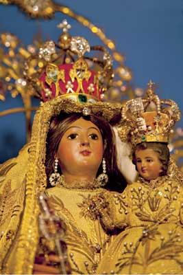
Two natural Indians of the Indian province of Barajagua, brothers Juan and Rodrigo de Hoyos, accompanied by slave boy Juan Moreno went in 1612 to the Peninsula El Ramon, where the saline are. When crossing on canoe the Bay of Nipe, they found the image of the Virgin of Charity floating in the waters.
She was moved by these men to the herd of Barajagua la Vieja, current town of Barajagua; they built the first house for her and worshiped the image in the company of twenty people who inhabited this seat. There the Virgin began performing miracles, and before the danger that the image may be lost in the hands of any of the aborigines who had found her, she was transferred to Real de Minas de Santiago del Prado, present town of El Cobre, the most important economic and political center in the east at that time.
The route followed along with the image is approximately in an area of more than two thousand square kilometers, stretching from the Bay of Nipe to the heights of Barajagua, and from this point to the town of El Cobre. Thus, in 1915 she was proclaimed Patroness of the Cuban people upon request of more than two thousand members of the Liberation Army.
From Nipe to Barajagua
The discovery of the Virgin of Charity, and subsequent worship in places that make this landscape is inextricably linked to the historical and social development of the territory. Following in the footsteps of archaeological sites, an indigenous cultural landscape is modeled in which these, and now its heritage, are ubiquitous, also impacting the toponymy and historical tradition.
To the south the situation changes, having the Santiago archaeological contexts little to offer in regard to Indians in the sixteenth and seventeenth centuries, perhaps because the proximity to the town of Santiago affected in greater level the native communities; in the same way distance, as seems to be in Barajagua, determined the rate of interaction perhaps less dramatic in terms of survival and indigenous integration.
Inclement weather and indiscriminate hand of man have resulted in part the degradation of the image of this historic landscape, but it is still recognizable and dazzling.
The great Bay of Nipe is an exceptional panorama on the country's geography and its location and natural conditions has been the engine of development of a large area dedicated to raising cattle and contraband trade at first, and then to the industry sugar and mining.
The site of access to the coast that the Hoyos brothers and Juan Moreno used to reach the French Key or Vigía (currently Cayo Obispo), and back of the saline with the three thirds of salt, in which they placed the image on a barbecue for immediately afterwards escort her to the herd of Barajagua, is today known as Cayo de la Virgen. It is located in Playa Morales, between the mouths of the rivers Nipe and Centeno. It is a promontory offshore inaccessible at that time when the tide rose and during rainy days, with a rough tongue of stony ground giving it access in dry weather. It is protected by native vegetation and endemic species inhabit it.
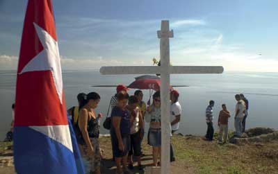
Currently in the uninhabited key there are remains of a chapel with a rustic wooden cross placed in 2009, which was presided by an image of the Virgin of Charity in bronze on a concrete base about five feet high. After 1959 this image was transferred to the sanctuary of El Cobre. At present it is planned to build a new chapel designed by artist Cosme Proenza.
 About two kilometers from the Cayo de la Virgen, inside the bay, Cayo Obispo is located, called in the seventeenth century French Key or Vigía, in which due to bad weather the stars ranchers of this beautiful story stayed overnight three nights. There is archaeological evidence found, and retains a dense vegetation. The whole landscape, according to neighbors who live nearby, was transformed by Hurricane Flora in 1963. They say that the coast was straight and when the tide went out you could go to the Cayo Obispo walking.
As for the peninsula of El Ramón, declared floristic reserve managed by Citma, small beaches, weeds and saline are preserved. In one of them, the smallest, located in Punta Negra, south of Canalito, it is said was where the Indians Hoyos collected salt, as has been known documentary that is the curdles. It has also been reported as an archaeological site.
The forests of tall trees do not longer exist: the area is covered by dense undergrowth and reforested with African acacias and mahogany. The water is salty. Since colonial times two wells were opened --in the Júcaro and El Ramón-- giving fresh water, but unpalatable. On the peninsula important Aboriginal and old runaway archaeological sites and ruins and pits of the place where the German raider in the service of Spain William Heastie lived are preserved. In the village of Canalito there is a small memorial to the issuance of Perrit (1869).
Elsewhere in the bay, historically known as Punta de Corojal, the port city of Antilla was founded in 1905, currently head of the municipality of the same name.
Between the Bay of Nipe and the heights of Barajagua there is a vast savannah. The hills of the site Barajagua la Vieja are part of Maniabón Heights. Today is a village of small farmers, settled on both sides of the Holguín-Mayari Road, next to Barajagua River at the foot of the Cemetery Hill, where archaeological Wastewalker exist. There, in the fifties, was built a small Catholic church, and for a few years before it appears a large Virgin of Charity, identified as the Virgin of Barajagua, space-turned-site of pilgrimage.
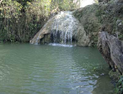
The Barajagua River, which runs through the village and the road, lost its original volume and is now a small stream, but still retains some of gallery forests and plants of great beauty with different species of vines and ferns. The jum of the river, from where the locals refer bringing the Virgin is a singular site though in part of the year, the waterfall is poor.
The path of Our Virgin of Charity
The historical evolution of four centuries of human performance in these parts has contributed to enriching the reported cultural historical values. Historic Sites of the War of Independence against Spain, the foundation in the territory of cities and sugar and mining settlements with American capital and immigration of labor, along with other facts related to worker and peasant struggles, are mixed with popular cultural events, customs and characteristics of the different places that make up the space traditions.
The path of the Virgin of Charity is today one of the most religious and tourist attractions that impact in the provinces of Holguin and Santiago de Cuba. The subsequent development of space has not prevented the preservation of old roads and solventia that link the specific sites that make up the journey, so it can be traveled on foot, animal transport and motor vehicles.
The most important of these roads, largely become highway is the Real Way to Cuba that parts from Mayari, bordering the Sierra de Nipe and passing Guaro, Bitirí --National Monument (MN) - Sojo, Biran (MN), Sabanilla Biran, Sao Corona (MN), Canapu, Mangos de Corazón, Cayo Rey, up to Miranda, there continues to the south to Santiago de Cuba and El Cobre.
Barajagua was a node between Holguin and these old roads. From here parts the known as Camino de los Indios, that joins the Real Mayari-Cuba to Sojo, and to the south passes through Saito, Alto del Cedro, to Cayo Rey Heights, where focus tied with Mayarí- Way Cuba.
On the 400th anniversary of the Marian presence in Cuba, significant sites that make up the Camino de la Virgen were declared a National Monument by Resolution no. 91 of the Monuments National Commission, by 'preserving material evidence of the event and therefore its high historical, ethnological and ethnographic value. "
Such sites were Cayo de la Virgen (Playa de Morales, southeast of the Bay of Nipe) and the town of Barajagua (municipality Cueto) and the town of El Cobre, which honors the patron saint of Cuba.
Clergy refers that the Virgin was found on October 27, 1612, the day that coincides with the arrival of Christopher Columbus in 1492, and with him the arrival of the first expressions of Christianity to the island. However, the Cuban people celebrate in September 8th the birthday of the Virgin as a national holiday. Of all attest the multiple testimonies gathered along the Camino de la Virgen. For the villagers, Our Lady of Charity has been and is among them.